August 14, 2023

Sometimes getting your hands on the right data for your project can be tricky.
EarthExplorer, run by the
USGS (United States Geological Survey), is one of the largest online databases for earth observation data. Millions of optical and radar images, maps, and more are available through this wonderful tool. Most of the data is free to download, but if you’re after images that haven’t yet been scanned you will need to pay $30 USD per file. Best of all, a lot of this data is perfect for uploading and viewing on
Soar!
Selecting your Search Criteria
Thankfully EarthExplorer’s search function is quite straightforward and easy to use, but also comes with more advanced options if that’s what you’re after. You can simply search by entering the name of the location you’d like to look at, using the area your screen is currently focused on, uploading a KML/KMZ and more! And of course, you can filter by date range and cloud cover.
Now we can dig into the datasets available. I won’t be able to cover them all, but I’ll talk through some of my favourites.
Aerial Imagery
Dating from the 1930s to now, you’ll find no shortage of aerial images on EarthExplorer. Most of this is over North America however, there is still some data available over parts of Europe, South America, Antarctica, and more. To learn more about all of the different datasets click on the ‘i’ icon to see more information.
If you’re searching for historical imagery the best dataset to check first is ‘Aerial Photo Single Frames’. This section alone has over 5.7 million images available! With 5.1 million of those currently being free to download. However, if you’re looking for the most up-to-date imagery your best option will be the NAIP (National Agriculture Imagery Program) dataset. As of writing this blog, there are over 1.7 million images available, with the most recent being taken in October 2022. Of course, this depends on the location of your search, but it’s worth taking a look!
If you can’t find what you’re after in the datasets above, try searching through the others and hopefully, you’ll be able to find what you’re looking for. These images make for great comparisons, and seeing how areas change over time!

Click on the image above to reveal the conversation
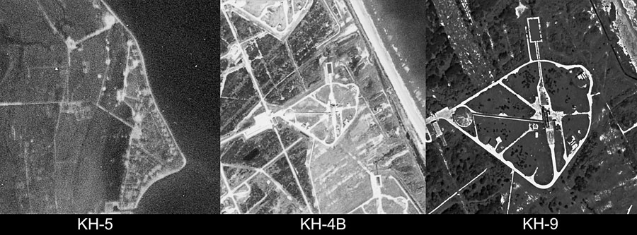
Declassified Data
This dataset is another goldmine for optical imagery. With over 1.3 million images spanning from the late-1960s through to the mid-1980s the declassified data is an excellent source of historical data, especially for international locations. Now, keep in mind that many of these images are still in the process of being scanned. However, if you really need one of the images you can pay $30 USD (+$5 USD for handling) to get an image scanned. Having done this many times it can be worth it. Depending on the time of year, you will usually get the image within a few weeks.
These images range from low resolution 140m/pixel images, up to 0.6m/pixel images. See the examples below.
Digital Elevation
This may be one of my personal favourite datasets. The SRTM (Shuttle Radar Topography Mission) was a payload flown aboard Space Shuttle Endeavour on STS-99 in February 2000 for 11 days. This led the instrument to capture 80% of Earth's surface between 60° north and 56° south. When it comes to spatial resolution there are both 3 arc-seconds (~90 meters) and 1 arc-seconds (~30 meters).
Once you find data that interests you, you can download it! To download the free imagery you will need to make an account. But don’t worry, you don’t get your email spammed! If the file is on the larger side, it may take some time to process on their side, but it will start downloading within a few minutes.
With millions of files that cover most of the Earth, data spanning many decades, and new data still being added, EarthExplorer is a priceless resource for mapping. And Soar is the perfect platform to allow this data to be accessible to anyone online.

This blog was written by:
Harry Stranger
Harry is a content specialist, mostly focusing on satellite imagery curation, processing, and analysing. In his free time outside of following the space industry he's passionate about landscape and astrophotography.