
We're back in your with another exciting update in the world of Soar. Take a look at our updated Satellite tab, a brand-new tool for georeferencing, and a year-end recap featuring what’s ahead in 2026. 🎅
Georeferencing might sound complex, but the idea is simple: it’s how you tell a map where it actually belongs on Earth. This week, we launched Georeferencer.ai - the fastest way to georeference any map online, completely free!
Right now, millions of maps online exist as simple flat images with no understanding of place. Once they’re georeferenced, they become more useful, meaningful, and enjoyable to explore. But until now, the process has been too technical and time-consuming for most people.
That’s what we set out to fix. By making georeferencing accessible, we hope people can finally give their images real spatial context, without special software or expertise needed! You can learn more here.
We built this tool to make georeferencing accessible to everyone. By placing a few points, you can align old map scans, aerial photos, and historical images to real-world coordinates, all from your browser.
As we continue to work on the platform, we took a fresh look at how to improve the Satellite tab. Until now, getting to satellite imagery required multiple clicks. Over the past few weeks, we’ve been streamlining the workflow so it’s faster and more informative for new users to access satellite imagery on Soar.
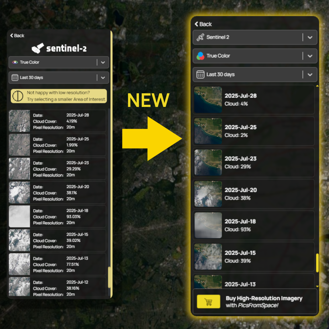
With the new design, you can jump straight into viewing imagery without first choosing a satellite provider. By default, it loads Sentinel - the most popular choice among our users. You can of course switch to Landsat at any time with the new dropdown. We've simplified unnecessary info and focused only on what you need: Easy, quick, satellite imagery!
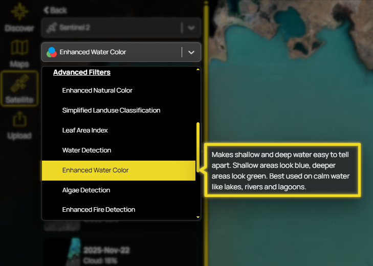
One of our favourite improvements is the new filter descriptions. Hover over any satellite filter and you’ll get a clear explanation of what it does and why it might be useful. This is great for making complex scripts easier for everyone to understand without knowing a thing about Satellite bands or GIS.
Read our Satellite Filter Guide here 👈
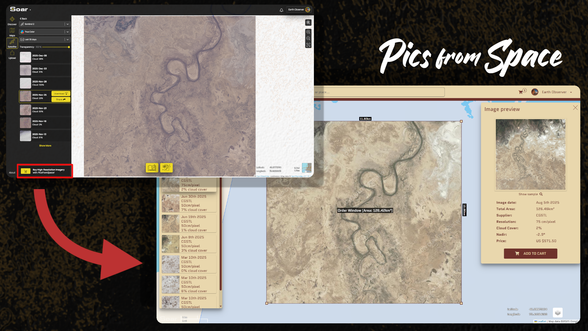
If you’re after higher-resolution imagery, you can jump directly to Pics from Space from the bottom button to purchase premium data. Even better, your selected area is automatically remembered, so when you open Pics from Space, there’s no need to redraw or search for your location again. Just click the button and you're ready to order!
These small changes make a big difference for putting the power of satellite imagery in people’s hands. We’ve also just released our full Satellite Guide, a great starting point for anyone new to satellite imagery. Give it a read!
Read our Full Satellite Guide here 👈
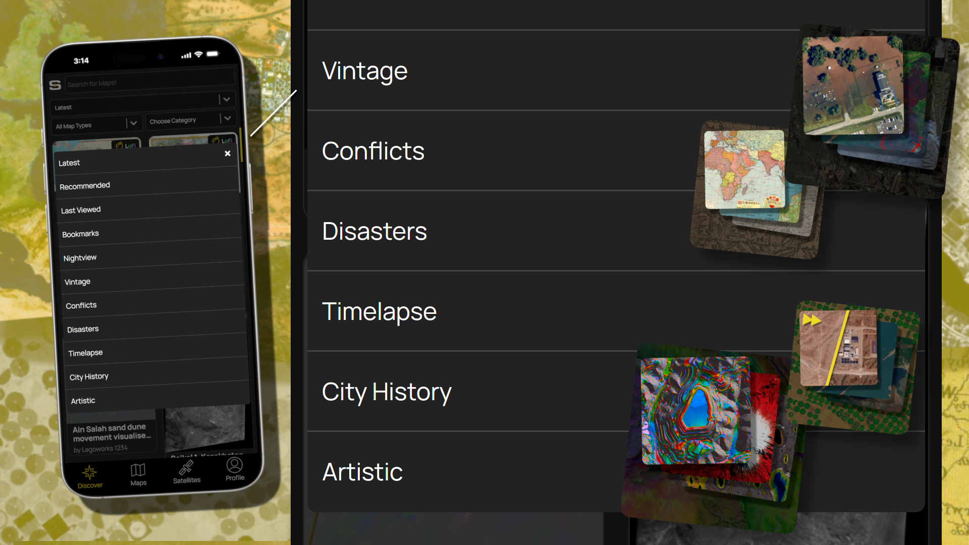
We’ve finally brought Bundles to Soar Mobile! Bundles are hand-curated collections of maps, grouped around specific themes. Since launching them on the main platform a few months ago, we’ve been steadily expanding each category, and now mobile users can explore them too! Just head to the Discover tab, tap the dropdown, and choose the bundle you’d like to browse. You can access Soar Mobile on the App Store or Google Play.
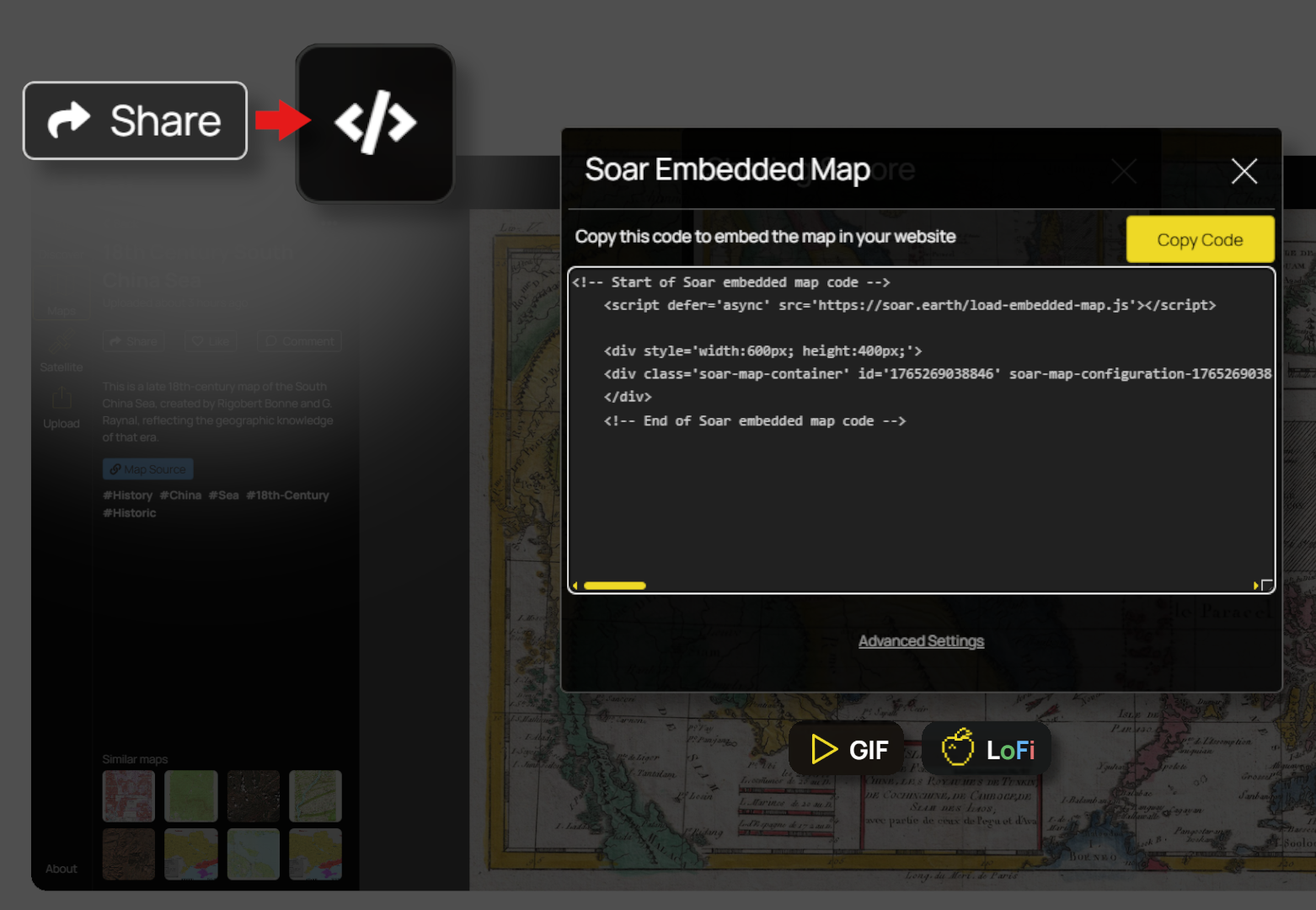
Embedded maps now support every map type! Previously, embeds only worked with georeferenced maps. Now they also include GIF maps and even LoFi Maps, making it easier than ever to add content from our library of more than 1 million maps anywhere, as an interactive viewer. Just hit the Share button on a map and select Embed, then copy the code into your website.
We shipped a lot this year, but through it all, one thing always stands out: the incredible maps uploaded by you, our community! Here’s a small selection of our favourite maps (In no particular order) uploaded in 2025. Be sure to show the creators some love by following them on Soar.
- Aerial Imagery of Blatten, Switzerland - May 30, 2025
- The Eye of Hurricane Melissa: October 28, 2025
- Wildfires in Los Angeles, USA - Jan 09, 2025
- Flooding Along the Iran - Pakistan Border: January 13, 2020
- Mount St. Helens - 1980-06-30
- Drying of Sawa Lake, Iraq - 2017 to 2022
As we close out the year, we’re excited to see where we are. Soar has grown not just in features, but also in the stories and discoveries found in maps from our community.
A few highlights from this year include:
- Over 1 million maps and satellite images on the platform!
- Bundles that make it easier to discover what kinds of maps live on Soar
- GIF tools that let anyone create timelapses from satellite imagery
- New social features, notifications, follows, and recommendations
Beyond that, we launched our blogs & tutorials, kick-started Map Mail, and worked even closer with the community to listen and grow together.
Soar will continue to grow and improve. Our global digital atlas expands every day, and the tools that make it easier to explore exist because of the community’s support, your feedback, and the amazing team here at Soar. Thank you for being part of this journey! 💪
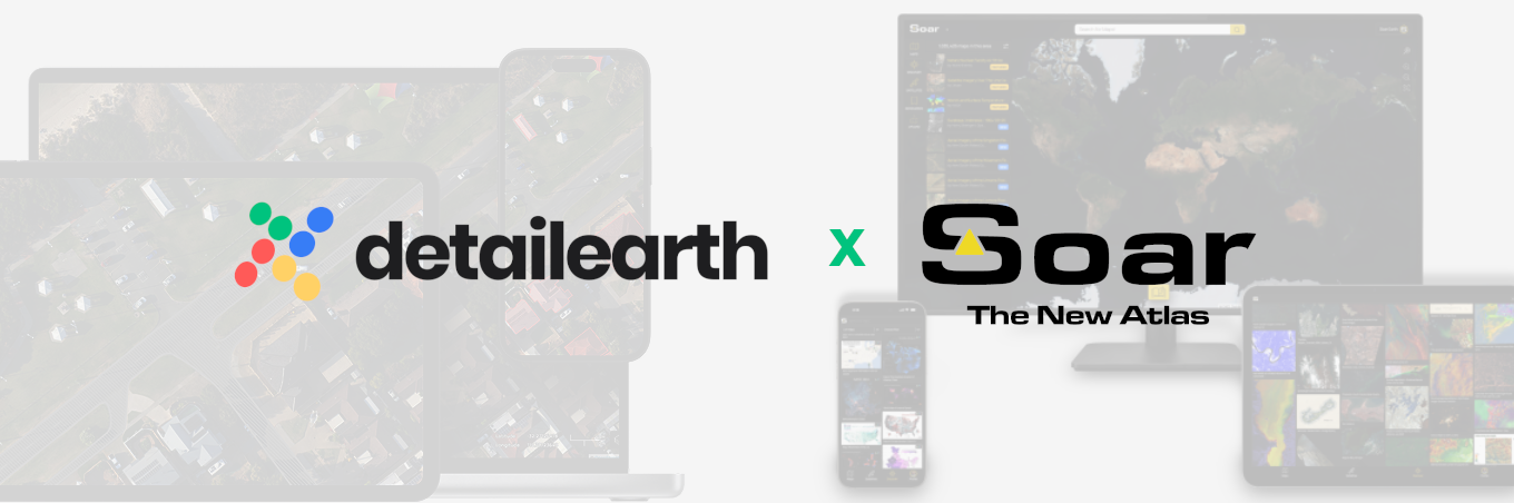
With our newly announced partnership with Detail Earth, we’re also opening the door to even richer ways to explore Australia and South-East Asia very soon. Hosting these maps on Soar will unlock new opportunities to expand what’s possible on the platform.
Read about Detail Earths partnership with Soar Atlas here 👈
With our newly announced partnership with Detail Earth, we’re also opening the door to even richer ways to explore Australia and South-East Asia very soon. Hosting these maps on Soar will unlock new opportunities to expand what’s possible on the platform.

"In 2025 we blasted past 1 million maps and satellite images on Soar. It feels wild to think back to the 100,000 mark, when I wondered, can this really get any bigger? Now here we are, a million strong! It still feels like we’re only just getting started.
What blows my mind most is the explosive diversity of data our community is now generating. If this is where we are today, I can’t wait to see how far we push the frontier in 2026."
Until next year mappers, may you all have a lovely holiday break! 🎅 Thanks for reading this edition of Map Mail! 👋
Disclaimer: This blog (and its screenshots) reflect Soar version 6.7. The interface and functions may differ in newer versions.